
One of the features of being so far behind with seminar reports is that I find myself writing about papers whose definitive versions have already been published.1 In some ways this is better than writing about work in progress, as it avoids the occasional issue about whether I’m letting people’s findings out before they’re ready for that to happen and means that my post becomes mere advertising (or, I suppose, warning, but I very rarely bother with reports on papers I can’t say good things about).2 In other ways this is worse: the people who are most interested may well already know about the work. But the Internet is large and not all of you are plugged in to the mains feed of the UK academy, so, I imagine people are still interested in Professor John Blair addressing the Medieval History Seminar in Oxford on 19th November 2012 with the title, “Land-Surveying in the Post-Roman West” even though you could now read it for yourselves?3 (I should note, by the way, that this means I’m skipping Annette Kehnel talking to the IHR Earlier Middle Ages Seminar on 7th October 2012 with the title, “Rituals of Power through the Ages – a History of Civilisation?”, not because it wasn’t fascinating but because Magistra et Mater covered it in depth some time ago and you can read about it at hers.)

Fragment of a Roman measuring rod at the Musée romain de Lausanne-Vidy, image from Wikimedia Commons
The whole reason that I spent three years in Oxford was ultimately that Professor Blair (whom I have to call John, really) had got money from the Leverhulme Trust to carry out a thorough-going survey of how settlement changed in Anglo-Saxon England, and I got lucky enough to be his stand-in. This left him free to bury himself in site plans, and as he did so, he told us, he began to notice a particular measurement coming up again and again. Now, this way madness can lie, as John was well aware. Not only do many medievalists not really understand numbers, so that they tend either to dismiss arguments that involve them or else accept them completely uncritically, but medievalists who do understand numbers have in some cases gone much further with them than many would credit, attributing immensely complex calculative abilities to those writing Latin prose in the period, er, just for example.4 At the far end of this lies work on monumental alignments, some of which is justly to be lampooned but some of which is just hard to assess.5 There is some limited work on Anglo-Saxon land measurement, which came up with a common ‘perch’ of 4·65 metres, but testing this has always been tricky because there’s always more material that might not conform.6 John, however, had got closer to being able to survey it all than anyone else ever has and saw what was, indeed, a ‘short perch’ of more or less 15 feet in many many places (although, interestingly, not in Wessex). Aware of the dangers, at this point he’d got a statistician involved and, giving them as close to raw figures as he could, was informed that there was a genuinely significant peak at the 4·6 m mark in them (pretty much 15 ft), as well as some other peaks at the multiples and fractions of that unit that were less demonstrable. Reassured that he wasn’t just seeing things, therefore, he then set out to find out how this was being used.

Diagram of Anglo-Saxon structures at Cowage Farm, Bremilham, with 15 ft grid overlaid, by John Blair
This part involved quite a lot of maps with grid overlays. Here, if anywhere, was the problem of subjectivity. Some of John’s example cases appeared more or less inarguable, although the problem of whether the archæological sequence was right in the first place and all the structures John was lining grids against had been there in the same period was lurking behind even these somewhere. This was easier to accept in some cases than others, especially given that John is famously willing to reinterpret other archæologists’ findings when he thinks there’s reason to do so.7 In other cases, though, I really wanted access to the files so I could see whether shifting the grid overlay by a metre or so one way or the other, or around by a few degrees, would not show up just as many matches, not that I would have been clear what it might mean for the theory if it had. Certainly, there were a few cases that made me think that John’s choice of what to align the grid to was possibly more arbitrary than was good for demonstration. This was much less so in the case of individual buildings (and a surprising number of square and rectilinear buildings could be relatively easily fitted to a 15 ft module, these including not least SS Peter & Paul Canterbury and All Saints Brixworth, whose bays and aisles snap nicely to it, with explanatory significance to which we’ll come), although quite a lot did so only in one dimension, being for example 15 ft wide but, say, 22 ft long, and most site maps provided one or two buildings that just failed to align at all, let alone be the ‘right’ size. The larger the map got the more this kind of non-conformity seemed to me to make the choice of where to lay the grid basically arbitrary, though the fact that some sites present several possibilities may work for John’s theory as much as against it and even, I suppose, open up the possibility of micro-phasing in their topography. Anyway, here was where I was least sure how much credit to give the idea.
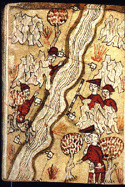
Fourteenth-century illustration of surveyors laying out grids over a river, from the Traité d’Arpentage of Bertrand Boisset
But, as long as even a small number of widely-spread and unconnected sites appear to conform at all, even if many others don’t, something needs explaining, and John had an explanation for how this might all be that, I think, makes his other cases easier to accept as possible. Unlike the prehistoric monument guys who have to assume that the knowledge of calculating such alignments and measurement techniques (not so much of lengths, which could just be a marked rod—perhaps the best bit of the paper was pictures of John himself messing about in open country with a fifteen-foot rod of his own manufacture seeing how hard it would be to lay out a village plan with it, the answer being not very—but of consistently precise right-angles) was transmitted somehow, John could point to texts, in the form of the manuals of Roman surveyors, agrimensores, copied in monastic contexts more or less throughout the period. We’ve already seen some of these texts on this blog, in fact, as such a manual exists from Santa Maria de Ripoll. Finding them in Anglo-Saxon contexts is a lot harder, but the fact that a lot of the uses of this 15-ft module are in fact ecclesiastical suggests that this is the easiest way to imagine its dissemination, monks with building projects putting into action the instructions of the ancients that they actually had written down.

Diagram of grid -planning in Anglo-Saxon churches, by John Blair
Fitting nicely with this was not just the number of his examples that John thought could be linked to monastic contexts (especially here the estates of Bishop Wilfrid of York (among other places) whose resort to Rome and Roman technical knowledge is well-documented), where possibly others might be less willing to assume a monastic church structure all over Anglo-Saxon England than he, but also the fact that this module is very hard to find in use between the eighth and tenth centuries.8 In other words, it is best attested during the first, ‘golden’ age of Anglo-Saxon monasticism and then in the age of the Anglo-Saxon monastic reform, both eras in which monastic learning was in fact involved in economic development and alterations to land-holding and land use.9 This works not least because, even though John was quite happy to find connections via which monks might actually have owned or operated many of the estates in question, you don’t actually need that as long as you accept that someone with a project to build a new village or whatever might be aware that the monks had information on such matters which they would probably impart on request. It would need to be quite high-culture monasteries to have a copy of the Ars gromatica in their collections, maybe – it doesn’t show up anywhere outside Santa Maria de Ripoll in Catalonia before the 13th century, says Michel Zimmermann though with various inevitable issues about patchy evidence survival, and Santa Maria is the biggest knowledge storehouse not just in the area but for some way beyond – but a mechanism for the transmission of this knowledge is visible, plausible and thus arguable in the cases where the evidence on the ground might not convince by itself.10

Different ways of laying out fields in the Ars gromatica text in Barcelona, Archivo de la Corona de Aragón, MS Ripoll 106, fo. 77v
There is a lot more that could be squeezed out of this, including the possibility of what would basically be tenements laid out for what would basically be serfs by monasteries, although the questions afterwards came substantially from a number of people who were very interested in the continuing use of the Roman foot, questions that made John’s contentions look much saner by comparison in fact, and to which he wisely ducked all answers, saying that the external verification of his 15-ft perch meant that it was the only measure he dared say was genuinely present in the data. John’s final publication of this is a meaty 49 pages in the quarto format Anglo-Saxon Studies in Archaeology and History, too, so I guess that a good bit more has been squeezed out in that version. If you want to know more, therefore, I can only recommend you have a look and get the information from the man himself!
1. How do people manage this? I gave a paper on Monday. If I knocked in all appropriate revisions and rewrote, I could have something ready to send out by the end of the month probably. It would then take at least six months to be reviewed, the changes that required would probably take me another three and then it would still be eighteen months on average till it got to print. So, some time in 2016? Even being a retired expert with a complete grasp of the evidence would only let me crunch three months out of that two-years-plus process. But Lesley Abrams of last post cut that lead time in half and John Blair, of this post, did even better…
2. This has been a matter of concern for me ever since I did my first one of these posts, seven years ago more or less. I always come back to the same answer: if someone is willing to talk about their work in public, anyone who really wants to misuse it can already get at it, and meanwhile, if I write about it more people know whose work to use respectfully on the subject… But it’s always a little dicey.
3. As J. Blair, “Grid-Planning in Anglo-Saxon Settlements: the short perch and the four-perch module” in Helena Hamerow (ed.), Anglo-Saxon Studies in Archaeology and History Vol. 18 (Oxford 2013), pp. 18-61.
4. By which I really mean David Howlett, British Books in Biblical Style (Dublin 1997), a six-hundred-plus page monster that rather defies evaluation, alleging deliberate arithmetical meter in a host of Insular Latin works and apparently only one of five such books Howlett now has on such questions.
5. For example, Charles Thomas, Christian Celts: messages and images (Stroud 1998), blisteringly reviewed by the normally-equable Thomas Owen Clancy in Innes Review Vol. 51 (2000), pp. 85-88, DOI 10.3366/inr.2000.51.1.85.
6 P. J. Huggins, “Anglo-Saxon timber building measurements: recent results” in Medieval Archaeology Vol. 35 (Leeds 1991), pp. 6-28.
7. E. g. J. Blair, “Palaces or minsters? Northampton and Cheddar reconsidered” in Anglo-Saxon England Vol. 25 (Cambridge 1996), pp. 97-121.
8. The former is of course the great minster debate, actually framed as such in Eric Cambridge & David Rollason, “Debate. The Pastoral Organization of the Anglo-Saxon Church: a Review of the ‘Minster Hypothesis’” in Early Medieval Europe Vol. 4 (Oxford 1995), pp. 87–104 & J. Blair, “Debate: Ecclesiastical Organization and Pastoral Care in Anglo-Saxon England”, ibid. pp. 193–212.
9. These threads both picked up and carefully woven into much else in J. Blair, The Church in Anglo-Saxon England (Oxford 2005), pp. 135-367, no less.
10. Michel Zimmermann, Écrire et lire en Catalogne (IXe-XIIIe siècles), Bibliothèque de la Casa de Velázquez 23 (Madrid 2003), 2 vols, II pp. 891-897 on the Ripoll manuscript and its milieu.


Pingback: Back at the Chester-le-Street church | Revealing Words
Pingback: Seminar CLIV: John Blair’s Ford Lectures I | A Corner of Tenth-Century Europe
Pingback: Seminar CLVIII: John Blair’s Ford Lectures, II | A Corner of Tenth-Century Europe
Pingback: Seminar CLXIII: John Blair’s Ford Lectures, IV | A Corner of Tenth-Century Europe
Pingback: Seminar CLXVI: debating with John Blair | A Corner of Tenth-Century Europe